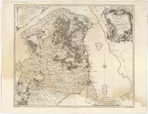
Den Nord - Ostlige Fierdedeel at Siaeland


 Disponible Holdings
 Section: Maps, plans and nautical charts
Title: Den Nord - Ostlige Fierdedeel at Siaeland / under det Kongle Viidenskabers Societets Direction ved rigtig Landmaaling optaget..., reduceret og tegnet at Caspar Wessel ; Stukket af Defehrt ; Martin Scripsit
Material or type of resouce Area: Escala [ca. 1:120000], 2 Geografiske Mule huor af 15 udgiore een Grad [= 12 cm]
Publication: [Kobenhavn ? (Copenhague) : Kongle Viidenskabers Societets Direction], 1771
Physical description: 1 mapa ; 56,5x66,5 cm en h. de 62,5x80,3 cm
Notes: Escalas gráficas de 2 almindelige Danske Mulle [= 12 cm], 2400 Alen [= 12 cm]. Coordenadas referidas al meridiano de Copenhague (O0#46'-E0#29'/N56#8'/N55#33'). Recuadro geográfico de 5' en 5'. Orientado con lis en rosa de 16 vientos prolongados
Relieve representado por normales
Tabla de signos convencionales para indicar núcleos de población de distinta categoria, caminos y líneas administrativas
Indica edificios mediante edificios de perfil, cultivos y masas forestales
Título enmarcado en cartela barroca con estandartes y blasón de tres leones
Sello en 'Seco del Depósito de la Guerra'
Materia / lugar / evento: Mapas generales
1771
Selandia (Isla)
UDC: 912(489-17) Selandia, isla)'1771'
489-17) Selandia, isla
Type of publication:
 Maps
Maps
Rights:
Préstamo:
Disponible
