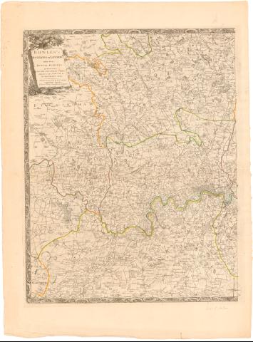
Bowles's Environs of London taken from actual surveys...


 Maps, plans and nautical charts
Bowles's Environs of London taken from actual surveys exhibiting all the new roads, parks seats of the nobility to... (178- ?)
Maps, plans and nautical charts
Bowles's Environs of London taken from actual surveys exhibiting all the new roads, parks seats of the nobility to... (178- ?)
 Disponible Holdings
 Section: Maps, plans and nautical charts
Title: Bowles's Environs of London taken from actual surveys exhibiting all the new roads, parks seats of the nobility to the present year / Caringhton, Bowles
Material or type of resouce Area: Escala [ca. 1:10000]
Publication: London : Printed for sold by the propietor Carington Bowles N 69 in St Pauls Church Yard, [178- ?]
Physical description: 1 mapa en 2 : col. ; 62x82 cm en h. de 76x114 cm
Notes: Orientado con lis en rosa de 6 vientos
Relieve de perfil
Indica el curso del río thamesis con flecha y el limite entre condados en color
Título enmarcado en cartela con motivos florales
Materia / lugar / evento: Planos de población
Siglo XVIII
Buckinghamshire
Berkshire
Surrey
Kent
Londres
Other authors: Bowles, Carrington, 1724-1793
UDC: 912:314(410-328 Inglaterra)'1780/1789'(084.3)
(410-328 Buckinghmashire)
(410-328 Berkshire)
(410-328 Surrey)
(410-328 Surrey)
(410-328 Kent)
(410-Londres)
Type of publication:
Maps
Rights:
Préstamo:
Disponible
