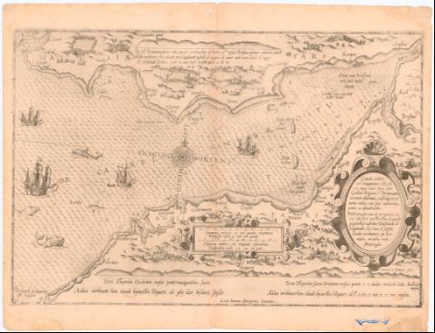
Beschryuinghe de vermaerde Canael oste svert van Briston...
Section: Maps, plans and nautical charts
Title: Beschryuinghe de vermaerde Canael oste svert van Briston de ganse gelegentheste tubchen Walblandt en Engelandt, olsve hem de selside Landem verthoonem op haer mylen windon ende selssde landom verthoonem op haer mylen windon ende streckinge = Canalis celebris vel navigations a Bristovio, at que totius situs inter Galliam Belgicam J. Britannian accurata deliniatio, eiusdema terrae verus vultus cum suis miliaribus ventis ac ascendentibus / Lucas Ioannes Aurigarius Inventor ; Ioannes a Dotecum, fecit
Material or type of resouce Area: Escala [ca. 1:370000], 5 Duntschen mulen tot 15 in con groedt [= 10 cm]
Publication: [Holanda] : [s.n.], [1584-1585]
Physical description: 1 carta náutica ; 32,5x52 cm en h. de 41x54 cm
Notes: Presenta además 1 perfil
Pertenece al Atlas 'Sphienglo der Zeevaer'. - 1584-1585. - XIX
Escala grafica de '6 Hispania miliair tot 17 1/2 invoer groedt' [= 10 cm] Orientado con lis en rosa de 32 vientos prolongados
Relieve de perfil y sondas batimetricas
Indica veriles, bajos fondeaderos y sondas batimétricas
Leyenda explicativa al verso del mapa
Titulo y escala enmarcado en cartela Renacentista
Representación de galeras y monstruos marinos
Procede de la 'Colección Rico y Sinobas'
Other authors: Waghenaer, Lucas Jansz (ca. 1533-1606)
Doetecum, Jan van
UDC: 912:551.46]:[629.9:528.9](26.06 Bristol)(410)'1584/1585'
26.06 Bristol)(410
Type of publication:
![]() Maps
Maps
Préstamo:
![]() Disponible
Disponible


