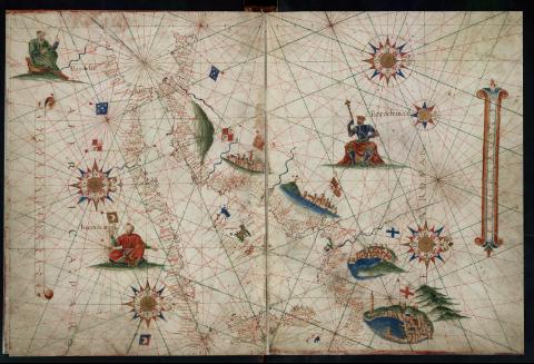
[Mediterráneo Occidental]


Section: Maps, plans and nautical charts
Title: [Mediterráneo Occidental] / [Ivan Ortis Valero]
Author: Ortis Valero, Ivan
[Mediterráneo Occidental (ca. 1575)] All editions
Characteristics of the edition: Español
Material or type of resouce Area: Escala indeterminada
Publication: [ca. 1575]
Physical description: 1 carta naútica : ms, col., perg. ; 40 x 27 cm
Content type: Imagen (cartográfica ; fija ; bidimensional ; visual)
Media type: sin mediación
Notes: Título redactado a partir del contenido del documento
Comprende España, Francia y el golfo de Génova al norte y las costas de Marruecos, Argelia y Túnez hasta Bizerta al sur, Baleares, Córcega y Cerdeña
Other titles: En: Ortis Valero, Ivan. [Atlas portulano]. - Producción: [alrededor de 1575]. - Carta 3
Materia / lugar / evento: Mediterráneo - Cartas náuticas - Obras anteriores a 1800
Genre / form: Cartas náuticas
Manuscritos
Cartas portulanas
UDC: (262.1)
Type of publication:
 Maps
Maps
Rights:
