[Atlas novus sive Tabulae Geographicae Totius Orbis]


 Disponible Holdings
 Section: Maps, plans and nautical charts
Uniform title: Mundo. Mapas generales. Varias escalas (1725)
Title: [Atlas novus sive Tabulae Geographicae Totius Orbis] / Matthaeum Seutter
Material or type of resouce Area: Varias escalas
Publication: [Augusta Videlicorum] : [s.n.], [ca. 1725]
Physical description: 1 atlas : 29 lám. col. ; 54 x 32 cm
Notes: Título propio tomado del catálogo del SGE: "Catálogo de atlas". 1962. P. 118
Relieve representado por símbolos
Señala vegetación
Elementos decorativos en cada lám
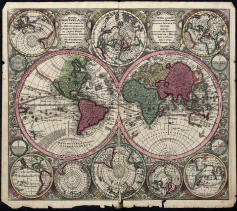
Contiene: [lám. 1]. Diverse Globi Terr-Aquei - [lám. 2]. Europa - [lám. 3]. Asia - [lám. 4]. Africa - [lám. 5]. America - [lám.6]. Portugallia et Algarbiae, Brasilia - [lám.7]. Hispania - [lám. 8]. Gallia - [lám. 9]. Angliae, Scotiae, Hiberniae - [lám. 10]. XVII Provinciae, Belgii sive Germaniae Inferioris - [lám. 11]. Belgii - [lám. 12]. Belgium Foederatum - [lám. 13]. Helvetia - [lám. 14]. Italiae - [lám. 15]. Siciliae - [lám. 16]. Imperium Romano Germanicum - [lám. 17]. Bohemia - [lám. 18]. Sueciae, Daniae et Norwegiae - [lám. 19]. Daniae Regnum - [lám. 20]. Poloniae Regnum et Magni Ducatus Lithuniae - [lám. 21]. Borussiae - [lám. 22]. Marchionat us Brandenburgensis Ducatus Pomeraniae et Ducatus Mecklenburgicus - [lám. 23-24]. Imperii Moscovitici - [lám. 25]. Hungariae - [lám. 26]. Maxima pars Danubii et praesertim Hungaria, Graecia, Morea et Archipelagi Insulae - [lám. 27]. Peloponnesus hodie Morea - [lám. 28]. Imperii Persici - [lám. 29]. Terra Sancta
Materia / lugar / evento: Mapas generales
Núcleos de población
Ríos
Montañas
Mares
Divisiones administrativas
Fronteras
Atlas
1725
Mundo
Other authors: Seutter, Matthaeus, 1678-1756
UDC: 100
Type of publication:
 Maps
Maps
Rights:
Préstamo:
Disponible
