[Atlas portulano]


 Disponible Holdings
 Section: Maps, plans and nautical charts
Title: [Atlas portulano] / Ivan Ortis Valero
Author: Ortis Valero, Ivan
Material or type of resouce Area: Escala indeterminada
Publication, Production, Distribution, etc.: Producción: [alrededor de 1575]
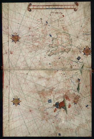
Physical description: 1 atlas : manuscrito, color, pergamino ; 20 x 26 cm
Notes: Título tomado del catálogo del Centro Geográfico del Ejército: "Catálogo de atlas", 1962, p. 3
Algunas de las cartas tienen escala de latitudes
Tronco de leguas, cuyas divisiones grandes parecen corresponder a medios grados, subdivididos en otras cinco divisiones
Orientado con lis en rosas de los vientos de 32 rumbos. Nudos de rumbos
Relieve representado por montes de perfil. Muy destacadas las vistas de ciudades en perspectiva caballera y los puertos más importantes en carmín. Representada la hidrografía. Abundante toponimia costera
Manuscrito en pergamino a tinta negra iluminado en azul, carmin, verde y ocre
Escritura gótica
Portada ilustrada con escena de un religioso implorando a Cristo Crucificado, con la leyenda: "D[omi]ne memento mei"
Sobre cada uno de los territorios, figuras de soberanos y estandartes de los diferentes reinos
Contains: [1. Océano Atlántico desde el Sur de España hasta el Golfo de Guinea] -- [2. Europa Occidental] -- [3. Mediterráneo Occidental] -- [4. Mediterráneo Occidental y Central] -- [5.Mediterráneo Oriental y Mar Negro]
Included records: [Europa Occidental] . - [Lugar de publicación no identificado], [ca. 1575]
[Mediterráneo Occidental y Central] . - [ca. 1575]
[...] Ver todos los registros incluidos (5)
Materia / lugar / evento: Atlas - Obras anteriores a 1800
Cartas náuticas - Obras anteriores a 1800
Type of publication:
 Maps
Maps
Rights:
Préstamo:
Disponible
