A Accurate Chart of the Bay of Biscay : with the...


 Maps, plans and nautical charts
A Accurate Chart of the Bay of Biscay : with the soundings taken in 1756 & 1757 by the French Friagate Anemone to... (1777)
Maps, plans and nautical charts
A Accurate Chart of the Bay of Biscay : with the soundings taken in 1756 & 1757 by the French Friagate Anemone to... (1777)
 Disponible Holdings
 Section: Maps, plans and nautical charts
Uniform title: CANTABRICO (Mar). Cartas náuticas. 1:897.000 (1777)
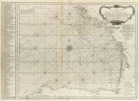
Title: A Accurate Chart of the Bay of Biscay : with the soundings taken in 1756 & 1757 by the French Friagate Anemone to Know for the soundings between Mohaut and Bayonne extend from shores the Quality of the Bottom [Mapa] / Done by order of the Minister of Marine to facilitate the Approach of ships to the Coast of France by the help of soundings ; by Mr Magin Engineer to th Marine ; Robert Sayer and John Bennet
Material or type of resouce Area: Escala [ca. 1:897000] (O 10° 05' 14'' -- O 00° 10' 14'' / N 48° 35' 00'' -- N 43° 00' 00'')
Publication: London : Robert Sayer and John Bennett, 1777
Physical description: 1 map. ; 71 x 100 cm pleg. 56 x 46 cm
Notes: En : "The East India Pilot, or Oriental Navigator", part. I, map. n°15
Documento graduado, longitud referida a los meridianos de: París, Azores, Ferro, Tenerife, Lizard, y Londres
Consta escala gráfica paralela al eje de latitud, de leguas marinas de 20 al grado
Describe detalladamente la toponímia costera
Contiene una relación de los sondeos realizados para la elaboración de la carta, indicados por clave numérica en digitos romanos
Incluye leyenda explicativa
Título enmarcado en cartela barroca
Materia / lugar / evento: Cartas náuticas
Batimetría
Other authors: Magin, M
Bennett, John
Sayer, Robert, 1725-1794
UDC: 912:551.46(261.2)"17"
261.2
Type of publication:
Maps
Rights:
Préstamo:
Disponible
