Plan of the islands of Querimbo, Oybo and Materno : on...


 Maps, plans and nautical charts
Plan of the islands of Querimbo, Oybo and Materno : on the eastern coast of Africa in 12 degrees 20 minutes south... (1778)
Maps, plans and nautical charts
Plan of the islands of Querimbo, Oybo and Materno : on the eastern coast of Africa in 12 degrees 20 minutes south... (1778)
 Disponible Holdings
 Section: Maps, plans and nautical charts
Uniform title: QUERIMBA (Mozambique) (Isla). Cartas náuticas. 1:248000 (1778)
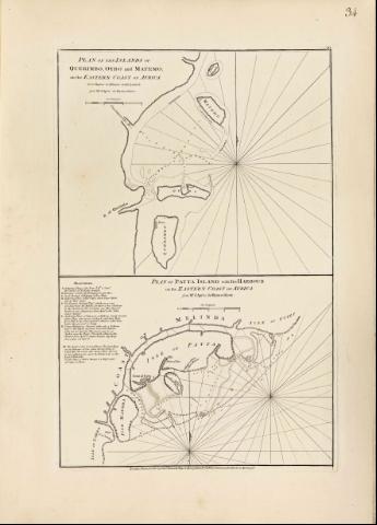
Title: Plan of the islands of Querimbo, Oybo and Materno : on the eastern coast of Africa in 12 degrees 20 minutes south latitude [Mapa] / from Mr d'Aprés de Mannevillette
Material or type of resouce Area: Escala [ca. 1:248000]
Publication: London : Robert Sayer and John Bennett, 1778
Physical description: 1 map. ; 27 x 33 cm, en h. de 62 x 45 cm
Notes: En : "The Easts India Pilot or oriental Navigator", part. I, map. n°34
Escala gráfica de tres leguas marinas de 6,7 cm de longitud
Orientado con media lis
Presenta análisis batimétrico de la zona comprendida entre las islas de Materno y Oybo, indicando a su vez la localización de fondeaderos
Documento acompañado de . "Plan of Patta island with ist harbour on the eastern coast of Africa " Escala [ca. 1:300000]
Materia / lugar / evento: Cartas náuticas
Islas
Ibo (Isla)
Matemo (Isla)
Other authors: Mannevillette, Jean Baptiste Nicolas Denis d'Après de
Bennett, John
Sayer, Robert, 1725-1794
UDC: 912:551.46]:551.42(679)"172
679
Type of publication:
Maps
Rights:
Préstamo:
Disponible
