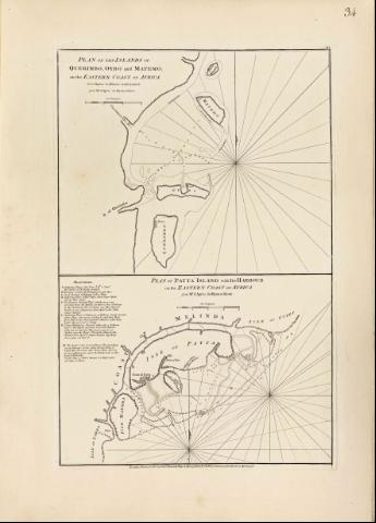
Plan of Patta Island : on the eastern coast of Africa


 Disponible Holdings
 Section: Maps, plans and nautical charts
Uniform title: PATTA (Kenya). Isla de. Cartas náuticas. 1778. 1:300000
Title: Plan of Patta Island : on the eastern coast of Africa [Mapa] / from Mr. D'Aprés de Mannevillette
Material or type of resouce Area: Escala [ca. 1:300000]
Publication: London : Robert Sayer and John Bennett, 1778
Physical description: 1 map. ; 22 x 33 cm, en h. de 62 x 45 cm
Notes: En :"The East India Pilot or oriental Navigator", part. I, map. n° 34
Escala gráfica de cuatro leguas marinas, de 7,4 cm de longitud
Orientado con media lis
Presenta análisis batimétrico de la zona
Describe nudo de rumbos
Contiene índice alfabético, explicativo del plano
Documento acompañado de : "Plan of the islands of Querimbo, Oybo and Materno, on the eastern coast of Africa" Escala [ca. 1:248000]
Other authors: Mannevillette, Jean Baptiste Nicolas Denis d'Après de
Bennett, John
Sayer, Robert, 1725-1794
UDC: 912:551.46]:551.42:627.22(676.2:22)"17"
676.2:22 Patta
Type of publication:
 Maps
Maps
Rights:
Préstamo:
Disponible
