A New Chart of the Islands of Scilly : with their...


 Maps, plans and nautical charts
A New Chart of the Islands of Scilly : with their soundings Channels and Sailing Marks (1779)
Maps, plans and nautical charts
A New Chart of the Islands of Scilly : with their soundings Channels and Sailing Marks (1779)
 Disponible Holdings
 Section: Maps, plans and nautical charts
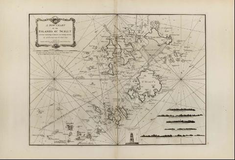
Title: A New Chart of the Islands of Scilly : with their soundings Channels and Sailing Marks [Mapa] / By A. Tovey and N. Ginver ; London Printed for Robt. Sayer and Jo. Bennett Chart-selleers No. 53 Fleet Street as the Act Directs 1st July 1779
Material or type of resouce Area: Escala [ca. 1:33000]
Publication: London : Robert Sayer and John Bennett, 1779
Physical description: 1 map. ; 49 x 67 cm
Notes: En : "The East India Pilot, or Oriental Navigator", part. I, map. no. 10
Consta escala gráfica de 3 millas náuticas, de 16,6 cm de longitud
Orientado con media lis
Presenta análisis batimétrico de la zona
Informa de la duración y altura de las mareas
Indica la localización de fondeaderos
Contiene varias perspectivas de la costa de las islas Scilly, más una representación gráfica del faro de : "Sta. Agnes Light House"
Materia / lugar / evento: Cartas náuticas
Islas
Perspectivas de costas
Other authors: Tovey, Abraham
Ginver, N
Bennett, John
Sayer, Robert, 1725-1794
UDC: 912:551.468]:742:551.42(410)"17"
410
Type of publication:
Maps
Rights:
Préstamo:
Disponible
