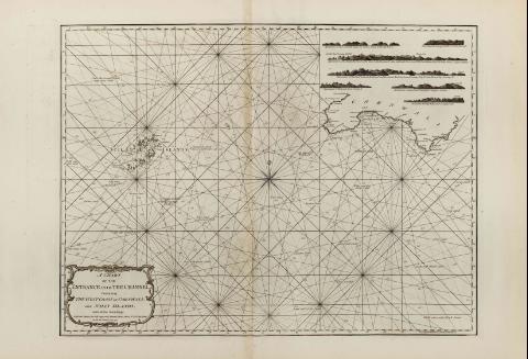
A Chart of the entrance into the Channel : Containing the...


 Maps, plans and nautical charts
A Chart of the entrance into the Channel : Containing the west coast of Cornwall, and Scilly Islands, with all the... (1779)
Maps, plans and nautical charts
A Chart of the entrance into the Channel : Containing the west coast of Cornwall, and Scilly Islands, with all the... (1779)
 Disponible Holdings
 Section: Maps, plans and nautical charts
Uniform title: LA MANCHA (Canal). Cartas náuticas. 1:257000 (1779)
Title: A Chart of the entrance into the Channel : Containing the west coast of Cornwall, and Scilly Islands, with all the Soundings / Printed for Robt. Sayer and Jo. Bennett chart sellers No. 53 Fleet Streetas the Act Directs Ist July 1779
Material or type of resouce Area: Escala [ca. 1:257000]
Publication: London : Robert Sayer and John Bennett, 1779
Physical description: 1 mapa ; 51 x 69 cm
Notes: Escala hallada a partir de la medición de un arco de meridiano terrestre de Londres: 1 minuto [= 18 cm].
Orientado con rosa y lis
Inserta siete perspectivas de la costa
Título enmarcado en cartela barroca
En: "The East India Pilot, or Oriental Navigator", part. I, mapa no. 11
Materia / lugar / evento: Cartas náuticas
Islas
Estrechos
Perspectivas de costas
1779
Cornwall
Gran Bretaña
Other authors: Bennett, John
Sayer, Robert, 1725-1794
UDC: 912:551.468]:742:551.42(410)"17"
410
Type of publication:
Maps
Rights:
Préstamo:
Disponible
