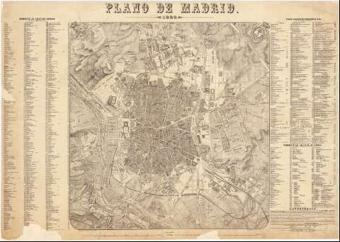
Plano de Madrid


Section: Maps, plans and nautical charts
Uniform title: Madrid. Planos de población. 1866. 1:10.000
Title: Plano de Madrid / La rectificacion interior, el aumento exterior y el dibujo, han sido hechos por D. Jose Pilar Morales... ; Pedro Peñas grabó
Material or type of resouce Area: Escala 1:10000
Publication: [Madrid] : Lit. de J. Aragón, Urosas l0, 1866
Physical description: 1 plan. : montado sobre tela ; 61 x 87 cm
Content type: Imagen cartográfica
Media type: computadora
Carrier type: recurso en línea
Notes: Representa cómo se estaba realizando el Ensanche de Madrid según el proyecto de Carlos María de Castro, pues refleja, por primera vez, la configuración del barrio de Argüelles, el solar para el nuevo proyecto de la Biblioteca Nacional y el depósito del Canal de Isabel II. En el Sur ya están configurados la zona del Puente de Toledo, el barrio de Peñuelas, el proyecto de ordenación de Delicias y Embajadores, y construidos el ferrocarril de Circunvalación que une las estaciones del Norte y Mediodía
Escala también dada en forma gráfica de 6000 pies castellanos y 2000 metros. Coordenadas del Observatorio de Madrid referidas al meridiano de su mismo nombre (E 0º00'00''/N 40º24'00'')
Relieve representado por normales y curvas de nivel equidistantes 10 metros
Clave alfanumérica para indicar, entre otros, los nombres de las calles (del interior y de las afueras), plazas, parroquias, conventos, colegios y escuelas, bibliotecas, hospitales, teatros y jardines, con su correspondiente retícula de localización (a razón de un kilómetro cuadrado por cuadrícula)
Nota explicativa en la que se señala que la base para la publicación del presente documento es un plano de Madrid levantado desde 1841 a 1846 por los ingenieros de Caminos D. Juan Merlo, D. Fernando Gutiérrez y D. Juan de Ribera
Decorado con los escudos de España y de la Villa
Other authors: Morales, José Pilar
Aragón, J
Peñas, Pedro
UDC: 912:[314(084.3)]+711(083.9)(460.27-2)"1866"
460.27-2
Type of publication:
 Maps
Maps
Rights:
Préstamo:
 Disponible
