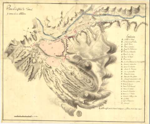
Plano de la Ciudad de Teruel y terreno de sus alrededores


 Disponible Holdings
 Section: Maps, plans and nautical charts
Uniform title: Teruel. Planos de población. 1:6800 (1811?)
Title: Plano de la Ciudad de Teruel y terreno de sus alrededores / Copiado en Cádiz por el Marques de Villacampo Ayudante 1° del Estado Mayor
Material or type of resouce Area: Escala [ca. 1:6800]. 600 varas castellanas [= 7,4 cm]
Publication: [1811?]
Physical description: 1 map. : ms., col., montado sobre tela ; 55,5 x 66,5 cm
Notes: Orientado con lis en cuadrante, con indicación de los puntos cardinales
Relieve representado por sombreado
Relación de las puertas, arrabales, edificios religiosos, puentes y fábrica de la ciudad y sus inmediaciones, indicados por clave alfabética, y el convento de los dominicos y el seminario por clave numérica
Consta el sello estampado del "Estado Mayor General"
Coloreado a la acuarela en azul, carmín y gris
Existe copia manuscrita de signatura SG. Ar.F-T.5-C.5-187
Materia / lugar / evento: Planos de población
Fortificaciones
Distritos
Edificios
1811
Teruel (Provincia)
Aragón
España
Other authors: Villacampo, Luis de Salamanca y Martínez de Pisón Marqués de
España. Ejército de Tierra. Cuerpo de Estado Mayor
UDC: (460.226 Teruel)
Type of publication:
 Maps
Maps
Rights:
Préstamo:
Disponible
