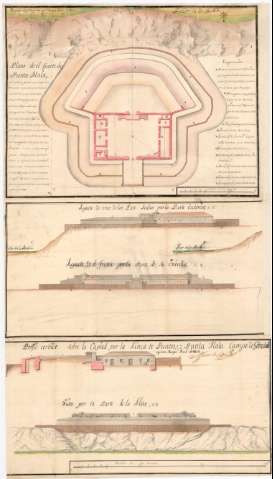
Plano de el fuerte de Punta Mala


Section: Maps, plans and nautical charts
Uniform title: CÁDIZ. Fuertes. 1:209 (1735)
Title: Plano de el fuerte de Punta Mala / Juan de Subeville
Material or type of resouce Area: Escala [ca. 1:209], 15 Tuesas [= 14 cm]
Publication: 1735 abril
Physical description: 1 plano : ms., col., montado sobre tela ; 129,8 x 50,3 cm, pleg. en 89,3 x 50,3 cm
Notes: Presenta 1 plano de la planta y 8 perfiles
Manuscrito firmado, rubricado y fechado en Campo de Gibraltar y Sn. Roque
Orientado con lis en rosa de ocho vientos prolongados
Relieve representado por sombreado
Manuscrito a plumilla en tinta negra y roja y colorea do a la acuarela en siena, sepia, verde y carmín
Relación de las principales partes de la fortificación indicada por clave alfabética
Nota relativa a la seguridad en la navegación y a la defensa del fuerte
Materia / lugar / evento: Fuertes
Planta arquitectónica
Perfiles
1735
Cádiz (Provincia)
Andalucía
Other authors: Subreville, Juan Pedro
UDC: (460.355 Cádiz)
Type of publication:
 Maps
Maps
Rights:
Préstamo:
 Disponible
