[Plano del fondeadero y dársenas de Cádiz]


 Maps, plans and nautical charts
[Plano del fondeadero y dársenas de Cádiz] (junio de 1869)
- Cerero y Sáenz, Rafael, 1834-1906
Maps, plans and nautical charts
[Plano del fondeadero y dársenas de Cádiz] (junio de 1869)
- Cerero y Sáenz, Rafael, 1834-1906
 Disponible Holdings
 Section: Maps, plans and nautical charts
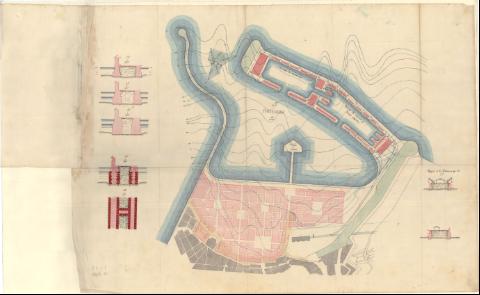
Title: [Plano del fondeadero y dársenas de Cádiz] / por el Coronel graduado D. Rafael Cerero
Author: Cerero y Sáenz, Rafael, 1834-1906
Material or type of resouce Area: Escala 1:4000 y Escala 1:400
Publication, Production, Distribution, etc.: Producción: junio de 1869
Physical description: 1 carta náutica y 7 perfiles : manuscrito, color, papel encerado ; 75,5 x 56, 5 cm en hoja 97,5 x 56,5 cm
Content type: Imagen cartográfica
Media type: computadora
Carrier type: recurso en línea
Notes: Orientada con nudo de ocho rumbos con flecha en el que se inserta una figura geométrica marcando un número de días en cada uno de ellos. - Relieve representado curvas de nivel sobre el mar. - Fondeadero, dásernas y núcleo urbano
Título tomado del documentos asociado al plano
Manuscrito a plumilla en tinta negra, azul y carmín
En el verso "3-5-7-10"
Plano adjunto al "Proyecto de mejora del Puerto de Cádiz, ejecutado en virtud de concesión otorgadda a favor de D. Ceáreo Cerero, por el Coronel graduado D. Rafael Cerero, Capitán de Ingenieros. Junio de 1869"
Contains: 1ª Fondeadero. - Escala 1:4000 ; 1ª Perfil de la Dársena por 1-2 .- 2 perfiles . 2ª a 6ª [Perfiles de las dársena]. - Escala 1:400
Materia / lugar / evento: Cádiz - Cartas náuticas
Genre / form: Cartas náuticas
UDC: (460.355 )
Type of publication:
Maps
Rights:
