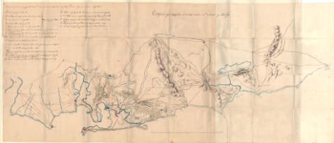
Croquis que comprende el terreno entre Sn. Lucar y Tarífa


 Disponible Holdings
 Section: Maps, plans and nautical charts
Title: Croquis que comprende el terreno entre Sn. Lucar y Tarífa
Material or type of resouce Area: Escala [1:82.000]. 4 Leguas [= 27,5 cm]
Publication, Production, Distribution, etc.: Producción: [Cádiz], [181--]
Physical description: 1 plano : manuscrito, color ; 132,5 x 57 cm
Content type: Imagen cartográfica
Media type: computadora
Carrier type: recurso en línea
Notes: En el margen superior izquierdo "Relacion de las Baterias Enemigas desde Puerto Rl. hasta Santi Petri con expresion de las piezas q. tienen , segun las noticias adquiridas"
En el margen derecho se Indican las baterias con su nombre y las piezas de artillería, en clave alfabética
Relieve representado por sombreado. -Representa las localidades más importantes en rojo. - Indica las vias de comunicación principales y caminos carreteros. - Señala lagunas y cursos de agua, molinos de guerra, bosques y zonas de cultivo
Manuscrito a plumilla en tintas negras, sepia y carmín e iluminado a la aguada, en verde para vegetación y arbolado y azul para hidrografía y zona costera
En el verso "3-3-9-2"
Materia / lugar / evento: Fortificaciones - Cádiz
Genre / form: Planos militares
UDC: (460.355 Cádiz)
Type of publication:
 Maps
Maps
Rights:
