Plano comprendido entre Renteria e Irún


Section: Maps, plans and nautical charts
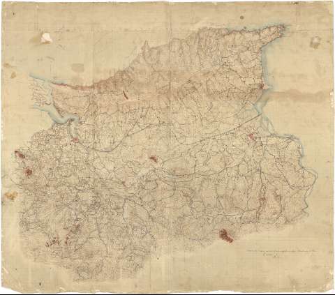
Title: Plano comprendido entre Renteria e Irún
Material or type of resouce Area: Escala 1:20000
Physical description: 1 mapa : ms., col., papel milimetrado, montado sobre tela ; 77,6 x 89,9 cm
Content type: Imagen cartográfica
Media type: computadora
Carrier type: recurso en línea
Notes: Comprende parte de los términos municipales de Rentería, Fuenterrabía, Oyarzun, Irún, Pasajes y Lezo, en la provincia de Guipúzcoa
Fecha tomada del catálogo del SGE: "Región Vasco-Navarra. Provincia de Guipúzcoa. Siglos XVI a XIX". 1969, p. 271
Orografia por curvas de nivel equidistantes 20 metros
Dibujado en varios colores
Ha servido para el levantamiento del mapa sobre la Guerra Carlista de 1874, según consta en el catálogo anteriormente citado
Materia / lugar / evento: Mapas topográficos
1874
Oyarzun
Lezo
Irún
Fuenterrabía
Pasajes de San Juan
Guipúzcoa
País Vasco
UDC: 912(466.212)"1874"
466.212 Rentería, Término Municipal
466.212 Oyarzun, Término Municipal
466.212 Lezo, Término Municipal
466.212 Irún, Término Municipal
466.212 Fuenterrabía, Término Municipal
466.212 Pasajes, Término Municipal
Type of publication:
 Maps
Maps
Rights:
Préstamo:
 Disponible
