Plan of Vingorla on the Malabar Coast : From a M.S. in...


 Maps, plans and nautical charts
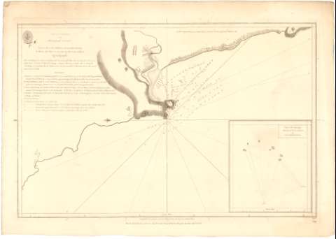
Plan of Vingorla on the Malabar Coast : From a M.S. in the Collection of Governor Horuby (1784)
Maps, plans and nautical charts
Plan of Vingorla on the Malabar Coast : From a M.S. in the Collection of Governor Horuby (1784)
 Disponible Holdings
 Section: Maps, plans and nautical charts
Uniform title: MALABAR (India) (Costa). Cartas náuticas. 1:23000 (1784)
Title: Plan of Vingorla on the Malabar Coast : From a M.S. in the Collection of Governor Horuby / to Whom this Plate is inscribed by His most obliged A. Dalrymple ; WH.
Material or type of resouce Area: Escala [ca. 1:23000], 5 nautic miles [= 40,4 cm]
Publication, Production, Distribution, etc.: Publicación: [London ?] : Publish'd according to Act. of Parliament by A. Dalaymple Scpr. 20th..., 1784
Fabricación: [London] : Sold by R.B. Bate 21 Poultry for the Lords Coummifsts. of the Admiralty by their Appointment, 1784
Physical description: 1 carta náutica ; 34,8x49 cm
Content type: Imagen cartográfica
Media type: computadora
Carrier type: recurso en línea
Notes: Orientado con lis en nudo de rumbos
Relieve representado por normales
Indica veriles, bajos, fondeaderos y sondas batimétricas
Relación de las principales fortificaciones y ciudades indicadas por clave alfabética
Inserta : Plan of the Principal Roks of Vingorla / by Capt. Joseph Muddart. - Escala [ca. 1:93000], 5 nautic miles [= 10 cm]
Sello de la Hydrographical Office
Other authors: Dalrymple, Alexander
Harrison, W
Huddart, Joseph
UDC: 912:551.46(540-328 Malabar)'1784'
540-328 Malabar
Type of publication:
Maps
Rights:
Préstamo:
Disponible
