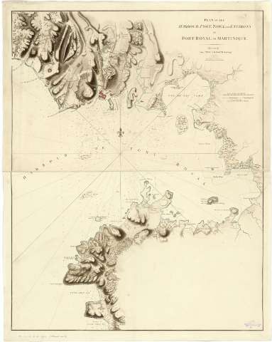
Plan of the Harbour, Fort Town and Environs of Fort Royal...


 Maps, plans and nautical charts
Plan of the Harbour, Fort Town and Environs of Fort Royal in Martinique (Septr 22 d. 1795)
Maps, plans and nautical charts
Plan of the Harbour, Fort Town and Environs of Fort Royal in Martinique (Septr 22 d. 1795)
 Disponible Holdings
 Section: Maps, plans and nautical charts
Uniform title: FORT ROYAL (Francia) (Bahía). Cartas náuticas. 1:23000 (1795)
Title: Plan of the Harbour, Fort Town and Environs of Fort Royal in Martinique / Drawn by Lieutt. William Booth, Royl. Engrs
Material or type of resouce Area: Escala [ca. 1:23000]
Publication: London : Published by W. Faden Geogr. to His Majesty and to His R.H. Prince of Wales Charing Gross, Septr 22 d. 1795
Physical description: 1 mapa : col, montado sobre tela88 x 70 cm ; 88 x 70 cm
Content type: Imagen cartográfica
Media type: computadora
Carrier type: recurso en línea
Notes: Escalas gráficas de 1 milla [= 8'0 cm] milla inglesa [= 8'1 cm] y de 600 toeas francesas [= 5'8 cm]. Orientado con lis en nudo de 32 rumbos
Orografía por sombreado. Sondas batimétricas
Se indican los fondeaderos, veriles y cayos. En tierra cabe destacarse la representación esquemática del plano de la actual población del fort-de-France y las fortificaciones adyacentes, caminos y fincas rústicas
Impreso en tinta azul, siena y roja
Procede de la colección de D. Manuel Rico y Sinobas
Materia / lugar / evento: Cartas náuticas
Planos de población
Fondeaderos
Islas
Fortificaciones
1795
Martinica
Fort-de-France (Bahía)
Caribe (Mar)
Other authors: Faden, William, 1749-1836
Boath, William
UDC: 912:551.46]:627.231:314(084.3)623.1:801.311(3)(729.81)"1795"
729.81
Type of publication:
Maps
Rights:
Préstamo:
Disponible
