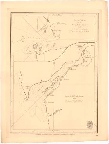
Plan of Choul on the Malabar Coast With the Drake's track...


 Maps, plans and nautical charts
Plan of Choul on the Malabar Coast With the Drake's track 19 July 1764 from an English M.S. ; Plan of Surat River... (1775)
Maps, plans and nautical charts
Plan of Choul on the Malabar Coast With the Drake's track 19 July 1764 from an English M.S. ; Plan of Surat River... (1775)
 Disponible Holdings
 Section: Maps, plans and nautical charts
Title: Plan of Choul on the Malabar Coast With the Drake's track 19 July 1764 from an English M.S. ; Plan of Surat River... / J. Russell sculp.
Material or type of resouce Area: Escala [ca. 1:500000], 5 Nautic Miles [= 20 cm]
Publication: [London?] : Published according to Act of Parliament by A. Dabrymple 15 Jan..., 1775
Physical description: 1 carta náutica ; 33,3 x 25,3 cm
Content type: Imagen cartográfica
Media type: computadora
Carrier type: recurso en línea
Notes: Orientado con lis en nudo de rumbos
Indica veriles, fondeaderos y sondas batimétricas
Sello de la Hydrographical Office
Other authors: Dabrymple, Alexander
Russell, John, 1745-1806
UDC: 912:[551.46:556.53](540-282.2 Surat)'1775'
(540-328 Malabar)
Type of publication:
Maps
Rights:
Préstamo:
Disponible
