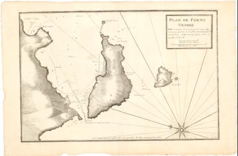
Plan de Porto Venere


Section: Maps, plans and nautical charts
Uniform title: PORTOVENERE (Italia). Cartas náuticas. 1:9300 (1732/1746)
Title: Plan de Porto Venere / par Jacques Ayrouard pilote real avec privilege du Roy ; gravé par Louis Corne
Material or type of resouce Area: Escala [ca. 1:9300], 200 Toises [= 4,2 cm]
Publication: [Francia ? : s.n., 1732-1746]
Physical description: 1 carta náutica ; 29,5x45,1 cm en h. de 35,1x53,1 cm
Notes: Pertenece al 'Recueil de plusieurs plans des Ports et Rades et de quelques cartes particulieres de la Mer Mediterranée'
Escala gráfica de una milla [= 7,8 cm]. Orientado con lis en rosa de 8 vientos prolongados
Relieve representado por sombreado
Indica veriles, fondeaderos y sondas batimétricas expresadas en brazas y pies
Al verso, manuscrito a lápiz, una nota sobre la pertenencia del plano al atlas ya mencionado
ITL
Materia / lugar / evento: Cartas náuticas
Puertos
Fondeaderos
Siglo XVIII
Palmaria (Isla)
Other authors: Ayrouard, Jacques
Corne, Louis
UDC: 912:551.46]:[627.22:627.231](45 Portovenere)'1732/1746'
(44 Palmaria, isla)
Type of publication:
 Maps
Maps
Rights:
Préstamo:
 Disponible
