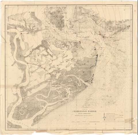
Charleston Harbor and its approaches : Showing the...


 Maps, plans and nautical charts
Charleston Harbor and its approaches : Showing the positions of the Rebel-Batteries 1863. (1863?)
Maps, plans and nautical charts
Charleston Harbor and its approaches : Showing the positions of the Rebel-Batteries 1863. (1863?)
 Disponible Holdings
 Section: Maps, plans and nautical charts
Uniform title: CHARLESTON (Estados Unidos) (Carolina del Sur) (Puerto). Operaciones bélicas. 1:30000 (1863?)
Title: Charleston Harbor and its approaches : Showing the positions of the Rebel-Batteries 1863. [Mapa] / U.S. Coast Survey ; A.D. Bache Supdt
Material or type of resouce Area: Escala [ca. 1:30000] (O 80°10' -- O 79°49' / N 32°48' -- N 32°38')
Publication: New York : J. Bien, 24 Vesey St., [1863?]
Physical description: 1 map. : col. ; 67 x 68 cm
Notes: Representación de la zona costera con plano de la ciudad y situación del fuerte Saint Michel indicando su radio de alcance defensivo y localizaciónde las baterías, trincheras y posiciones de la flota de ambos ejércitos; así como la primera y segunda línea de defensa de las fuerzas confederadas
Escala gráfica de 2 millas estatutarias [= 10'7 cm]. Sin especificación del meridiano de origen, que probablemente sea Greenwich. Red geográfica de 1° en 1°
Se señalan las sondas batimétricas, calidad de fondo, corrientes marinas y lineas de enfilación al puerto
Tabla de signos convencionales y colores empleados en el mapa (rojo lo referente a las secesionistas y azul para los federales)
Materia / lugar / evento: Operaciones bélicas
Puertos
Estrategia militar
Fortificaciones
Corrientes oceánicas
1863
Carolina del Sur
Estados Unidos
UDC: 912:355.4:355.43:355.43:623.1:551.46:551.465(757:26.04)"1863"
757:26.04 Charleston
Type of publication:
Maps
Rights:
Préstamo:
Disponible
