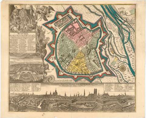
Munchen ; die weitberuhmt prechting und wohl fortifiarte...


 Maps, plans and nautical charts
Munchen ; die weitberuhmt prechting und wohl fortifiarte chur Furste... (1730 ?)
Maps, plans and nautical charts
Munchen ; die weitberuhmt prechting und wohl fortifiarte chur Furste... (1730 ?)
 Disponible Holdings
 Section: Maps, plans and nautical charts
Title: Munchen ; die weitberuhmt prechting und wohl fortifiarte chur Furste... / Matth. Seutler Kays ceogr in Augspurg
Material or type of resouce Area: Escala Indeterminada
Publication: [Alemania : [Editor no identificado], 1730 ?]
Physical description: 1 plano : col. ; 49x57 cm en h. de 53x65 cm
Content type: Imagen cartográfica
Media type: computadora
Carrier type: recurso en línea
Notes: Presenta además dos vistas de edificios de Munich
Orientado con lis en rosa de 32 vientos
Relación de los principales edificios de la ciudad indicados por clave alfabética y numérica
Titulo enmarcado en cartela barroca con escudo y figuras
Materia / lugar / evento: Planos de población
Fortificaciones
1730
Other authors: Seutter, Matthaeus, 1678-1756
UDC: 912:314(430 Munich)'1730'(084.3)
912:623.2(430 Munich)'1730'
430 Munich
Type of publication:
Maps
Rights:
Préstamo:
Disponible
