A Chart of the Mahé and Amirantes islands : with their...


 Maps, plans and nautical charts
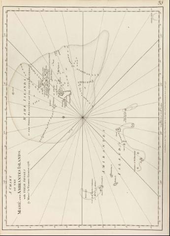
A Chart of the Mahé and Amirantes islands : with their shoals (1778)
Maps, plans and nautical charts
A Chart of the Mahé and Amirantes islands : with their shoals (1778)
 Disponible Holdings
 Section: Maps, plans and nautical charts
Title: A Chart of the Mahé and Amirantes islands : with their shoals [Mapa] / by Monsr le Vicomte Grenier 1776
Material or type of resouce Area: Escala [ca. 1:875000]
Publication: London : Robert Sayer and John Bennett, 1778
Physical description: 1 map. ; 43 x 58 cm
Notes: En : "The East India Pilot or oriental Navigator", part I, map. n° 35
Documento graduado, longitud tomada respecto del meridiano de Londres
Escala hallada a partir de un grado de latitud, siendo éste de 12,8 cm sobre el mapa
Orientado con lis
Presenta análisis batimétrico de la zona
Describe nudos de rumbos
Indica la localización de fondeaderos
Materia / lugar / evento: Cartas náuticas
Islas
Amirantes (Islas)
Other authors: Grenier, Jacques-Raymond
Bennett, John
Sayer, Robert, 1725-1794
UDC: 912:551.46]:551.42(696:22)"17"
696:22
Type of publication:
Maps
Rights:
Préstamo:
Disponible
