A New and accurate chart of the mouth of the Thames and...


 Maps, plans and nautical charts
A New and accurate chart of the mouth of the Thames and its entrances : viz ; the Kings the Queens and South... (1785)
Maps, plans and nautical charts
A New and accurate chart of the mouth of the Thames and its entrances : viz ; the Kings the Queens and South... (1785)
 Disponible Holdings
 Section: Maps, plans and nautical charts
Uniform title: TAMESIS (Río). Cartas náuticas (1785). 1:94000
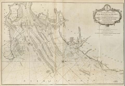
Title: A New and accurate chart of the mouth of the Thames and its entrances : viz ; the Kings the Queens and South channels from the Nove to Oxford Newsand the North Foreland [Mapa] / Improved by James Grosvenor, Pilot and by John Bean Haster of the Buoy Yacht, London Printed for Robert Sayer and John Bennet Chart- sellers Fleet Street, as the Act directs, Septemr. 1st 1785
Material or type of resouce Area: Escala [ca. 1:94000]
Publication: London : robert Sayer and John Bennett, 1785
Physical description: 1 map. ; 68 x 101 cm, pleg. 59 x 46 cm
Notes: En : "The East-India Pilot, or Oriental Navigator", part. I, map. no. 2
Consta escala gráfica de 4 leguas náuticas ó 12 millas, [= 20,5 cm]
Presenta análisis batimétrico de la desembocadura del río Támesis
Orientado con rosa y lis, indicando variación magnética
Título enmarcado en cartela barroca
Indica la altura y dirección de las mareas mediante dígitos romanos
Materia / lugar / evento: Cartas náuticas
Desembocaduras de ríos
Other authors: Grosvenor, James
Bean, John
Bennett, John
Sayer, Robert, 1725-1794
UDC: 912:551.46]:556.54(419)"17"
410:242 Támesis
Type of publication:
Maps
Rights:
Préstamo:
Disponible
