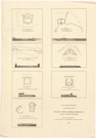
Plans & Views of Rebel Defences Coast of South Carolina


 Disponible Holdings
 Section: Maps, plans and nautical charts
Title: Plans & Views of Rebel Defences Coast of South Carolina [Mapa] / Drawn by E. Willenbucher under the direction of C. O. Boutelle Assist. U.S. Coast Survey 1862 ; U.S. Coast Survey A. D. Bache Sup'dt
Material or type of resouce Area: Escalas dif
Publication: Philada [i.e. Philadelphia] : Bowen & Co. lith., 1862?
Physical description: 7 plan. en 1 h. ; 17 x 17 o menor , h. de 67 x 46 cm
Notes: Consta de los planos y vistas de los siguientes fuertes : "Fort "Walker"- Hilton Head Isl. D.S.C.".- Escala 1:2000. "Ground plan and view of Fort on Botany-Bay Isld. North Edisto R.".- Escala 1:2000. "Fort on Sam's Point, Coosaw River S.C.".- Escala 1:1000. "Ground Plan and wiew of Fort on Bay point .- South Edisto R.S.C.".- Escala 1:1000. "Plan and view of Fort "Beauregard"-Bay Point S.C.".- Escala 1:2000. "Plan and View of Fort on otter Isld Point.-St. Helena Sound S.C.".- Escala 1:1600. "Fort on Fenwichk's Island S.C.".- Escala 1:1000
Materia / lugar / evento: Fortificaciones
Other authors: Bache, A. D, 1806-1867
Willenbucher, I
Estados Unidos. Coast Survey
Bowen & Co. (Philadelphia)
UDC: 912:623.6:623.1(757)"1862"
757
Type of publication:
 Maps
Maps
Rights:
Préstamo:
Disponible
