Marruecos : región S.O.al sur del río Tensift


 Maps, plans and nautical charts
Marruecos : región S.O.al sur del río Tensift (1914)
- Alvarez y Ardanuy, Eduardo, 1849-
Maps, plans and nautical charts
Marruecos : región S.O.al sur del río Tensift (1914)
- Alvarez y Ardanuy, Eduardo, 1849-
 Disponible Holdings
 Section: Maps, plans and nautical charts
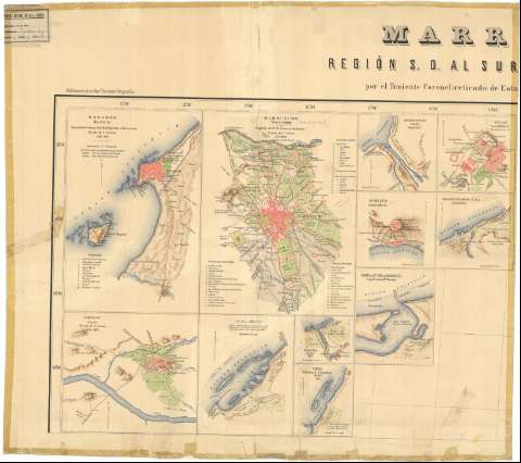
Title: Marruecos : región S.O.al sur del río Tensift / por Eduardo Alvarez Ardanuy ; dibujado y grabado por F. Noriega... [et al.], grabadores del Instituto Geográfico y Estadístico
Author: Alvarez y Ardanuy, Eduardo, 1849-
[Región S.O. al sur del río Tensift] All editions
Characteristics of the edition: 1914. 1:500.000. Español
Material or type of resouce Area: Escala 1:500.000
Publication: [Madrid?] : Instituto Geográfico y Estadístico, 1914
Physical description: 1 mapa en 4 h. : lit., col. ; en h. de 69 x 76 cm o menos
Content type: Imagen cartográfica
Media type: computadora
Carrier type: recurso en línea
Notes: Meridianos de origen: Madrid y Greenwich; márgenes graduados
Relieve representado por sombrado y costas con un fino rayado
Tabla de signos convencionales para indicar ciudades, ruinas, fuentes, pozos, lugares de posible desembarco e itinerarios reconocidos por españoles, por extranjeros y muy a la ligera
En el margen superior: "Publicación de la Real Sociedad Geográfica con auxilio del Ministerio de Estado"
En el margen inferior del mapa: "Advertencias"; "Observaciones sobre los planos" y "Nota sobre los itinerarios de Mogador a Marrakex y de Marraquex a Mazagan"
Incluye los siguientes planos y mapas: 1. Mogador (Es Suira) / Comisión del Cuerpo del Estado Mayor de Marruecos. - 1895. - 1:20.000. - 30 x 20 cm. -- 2. Marruecos (Marrakex) / Alvarez Ardanuy. - 1894. - 1:50.000. - 30 x 20 cm. -- 3. Desembocadura del Uad Dra / Gatell. - 1865. - 1:50.000. - 12 x 12 cm. -- 4. Aguelmin / Gatell. - 1864-65. - 1:10.000. - 12 x 12 cm. -- 5. Agadir Igur /Gatell. - 1864-65. - 1:20.000. - 12 x 12 cm. -- 6. Saibajarse o Saheb El Harxa / Gatell. - 1866. - 1:20.000. - 12 x 12 cm. -- 6. Puerto de Sta Cruz de Mar Pequeña / según Antonio Mª Manrique. - [ca. 1:2.850]. - 15 x 12 cm. -- 7. Tarudant / Gatell. - 1864. - 1:40.000. - 18 x 20 cm. -- 8. Uiná o Méano / Gatell. - 1.10.000. - 18 x 15 cm. -- 9. Uad-Xebika / Gatell. - 1:50.000. - 7 x 9 cm. -- 10. Tarfaya / Gatell. - 1865. - 1:20.000. 11 x 9 cm. -- 11. Asaka / E.M. Jaudenes. - 1883. - 1: 50.000. - 11 x 11 cm. -- 12. Uadkesis / Jaudenes. - 1883. - 1:40.000. - 11 x 11 cm. -- 13. Ifni / Jaudenes. - 1883. - 1:50.000. - 11 x 15 cm. -- 14. Sid Mohamed BenAbd-Al-Lah / Jaudenes. - 1883. - 1:40.000. - 11 x 10 cm. Todos ellos orientados con flecha
Materia / lugar / evento: Reconocimiento del terreno
Itinerarios
1914
Marruecos
Marruecos (Protectorado Español)
Marruecos (Protectorado Francés)
Genre / form: Mapas generales
Planos de población
Other authors: Noriega, F
Instituto Geográfico y Estadístico (España)
UDC: (64 Marruecos SO.)
Type of publication:
Maps
Rights:
Préstamo:
Disponible
