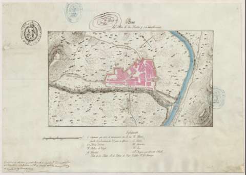
Plano del Mas de las Matas y sus inmediaciones


 Disponible Holdings
 Section: Maps, plans and nautical charts
Uniform title: MAS DE LAS MATAS (Teruel). Planos de población. 1:5.065 (1840)
Title: Plano del Mas de las Matas y sus inmediaciones
Material or type of resouce Area: Escala [ca. 1:5.065], 1.000 ps. [= 5'5 cm]
Publication: [1840?]
Physical description: 1 plano : ms., col., montado sobre tela ; 26'6x37'8 cm
Content type: Imagen cartográfica
Media type: computadora
Carrier type: recurso en línea
Notes: Orientado con lis, N. al NO.
Relieve representado por normales
Indicados caminos
Figura en el margen inferior: 'Mas de las Matas 19 de Febrero de 1840 = F. Cortes = V.B. = Bu...'
Manuscrito a plumilla en tinta negra y roja, iluminado a la acuarela en carmín, azul y siena
Explicación de las claves alfabéticas
Figura en el ángulo inferior izquierdo: 'El Original de este plano y el del Reducto de Seguridad fueron dirigidos al Ministerio de la Guerra en 26 de Mayo de 1840, acompañados de copia de las Descripciones'
Reproducción digital. Madrid : Ministerio de Defensa. Archivo General Militar de Madrid
Materia / lugar / evento: Teruel (Provincia)
UDC: 465.23 Mas de las Matas
Type of publication:
 Maps
Maps
Rights:
Préstamo:
Disponible
