Ayuntamiento de Redueña


Section: Maps, plans and nautical charts
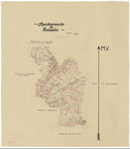
Title: Ayuntamiento de Redueña / Instituto Geográfico y Catastral
Material or type of resouce Area: Escala 1:25000
Publication: [194-]
Physical description: 1 map. : ms., col., papel cebolla ; 41 x 36 cm o menos
Content type: Imagen cartográfica
Media type: computadora
Carrier type: recurso en línea
Notes: Manuscrito en varias tintas
Orientado con flecha
Relieve representado por curvas de nivel equidistantes 10 metros y puntos acotados
Materia / lugar / evento: Mapas topográficos
Madrid
Other authors: Instituto Geográfico y Catastral (España)
UDC: 912.43(460.27)"19"
460.27Redueña
Type of publication:
 Maps
Maps
Rights:
Archivo Cartográfico de Estudios Geográficos del Centro Geográfico del Ejército
Location: AR — Call number: Ar.C-T.4-C.1-179 — Código de barras: 2215108
Préstamo:
 Disponible

© Ministerio de Defensa de España
P. de la Castellana, 109 28071 Madrid.
Tlf: (34) 91 395 50 00
Email: patrimonio.cultural@oc.mde.es