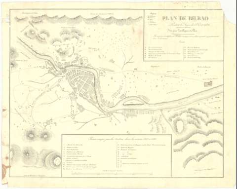
Plan de Bilbao pendant les Siéges de 1835 et 1836


 Disponible Holdings
 Section: Maps, plans and nautical charts
Uniform title: BILBAO (Vizcaya). Asedios. 1:7.284 (1836)
Title: Plan de Bilbao pendant les Siéges de 1835 et 1836
Material or type of resouce Area: Escala [ca 1:7.284], 4000 pies castellanos [= 15,3 cm]
Publication: Bayonne : Lith. de Bernain, [18--?]
Physical description: 1 plano ; 36x46 cm
Content type: Imagen cartográfica
Media type: computadora
Carrier type: recurso en línea
Notes: Orientado con flecha, N. al SE.
Relieve representado por normales
Arbolado e Hidrografía
Toponímia. Indicados caminos
Explicación de la clave alfabética para indicar las fortificación y clave numérica para indicar los puntos ocupados por los carlitas durante los años 1835-1836
Figura tabla de signos convencionales
Figura nota debajo del titulo: 'Note pour L'intelligence du Plau. Les maisons et édificos de Bilbao marqués d'une leltre capitale appartenaient aux Christinos'
Materia / lugar / evento: Asedios
Guerras carlistas
Planos de población
1836
Vizcaya
UDC: 466.1 Bilbao
Type of publication:
 Maps
Maps
Rights:
Préstamo:
Disponible
