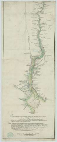
Plano reducido del río Uruguay desde los 31º de latitud...


 Maps, plans and nautical charts
Plano reducido del río Uruguay desde los 31º de latitud hasta su desagüe en el de la Plata (1801)
Maps, plans and nautical charts
Plano reducido del río Uruguay desde los 31º de latitud hasta su desagüe en el de la Plata (1801)
 Disponible Holdings
 Section: Maps, plans and nautical charts
Uniform title: URUGUAY. Mapas físicos. 1:42087 (1801)
Title: Plano reducido del río Uruguay desde los 31º de latitud hasta su desagüe en el de la Plata / Por el teniente de fragat D. Andrés de Oyarvide
Material or type of resouce Area: Escala [ca. 1:42.087]. 30 millas marinas [= 9,9 cm]
Publication: 1801
Physical description: 1 mapa : ms., col., montado sobre tela ; 73 x 28 cm
Content type: Imagen cartográfica
Media type: computadora
Carrier type: recurso en línea
Notes: Manuscrito a plumilla en tinta negra y coloreado a la acuarela en verde, marrón y carmín
Indica sondas batimétricas
Incluye una nota explicativa
Sello del Depósito General Topográfico de Ingenieros
Materia / lugar / evento: Mapas generales
Ríos
Desembocaduras de ríos
1801
Uruguay
Other authors: Oyarvide, Andrés de
UDC: 899
Type of publication:
Maps
Rights:
Préstamo:
Disponible
