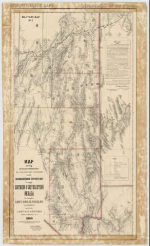
Map showing detoiled topography of the country traversed...


 Maps, plans and nautical charts
Map showing detoiled topography of the country traversed by the reconnaissance expedition through southern &... (1870)
Maps, plans and nautical charts
Map showing detoiled topography of the country traversed by the reconnaissance expedition through southern &... (1870)
 Disponible Holdings
 Section: Maps, plans and nautical charts
Title: Map showing detoiled topography of the country traversed by the reconnaissance expedition through southern & southeastern Nevada / in charge of Lieut. Geo. M. Wheeler U.S. Engineers ; Assisted by lieut. O.W. Lockwood Corps of engineers U.S.A. 1869 ; P.W. Hamel chief topographer an draughtsman
Material or type of resouce Area: Escala [ca. 1:760320], 1 inch to 12 miles (O 117°00'00''--O 113°00'00''/N 41°40'30''--N 35°40'00'')
Publication: California : Published at the Engineer Office, 1870
Physical description: 1 mapa : col. ; 91 x 50 cm
Content type: Imagen cartográfica
Media type: computadora
Carrier type: recurso en línea
Series: (Recunaissuce maps. Military map)
Notes: Escala también dada en forma gráfica de 30 millas legales [= 5'9 cm]
Relieve por normales y puntos acotados
Tabla de signos convencionales para diferentes núcleos de población y puntos de esta zona
Límites entre condados y distritos diferenciados por color
En nota se informa sobre las características del área representada
Materia / lugar / evento: Mapas generales
Divisiones administrativas
1869
1870
Other authors: Wheeler, George Montague
Lockwood, O.W
Hamel, P.W
Estados Unidos. Army. Corps of Engineers. Engineer Office
UDC: 793-12
Type of publication:
Maps
Rights:
Préstamo:
Disponible
