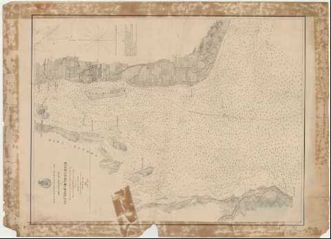
Preliminary Chart of Mouth Detroit River


 Disponible Holdings
 Section: Maps, plans and nautical charts
Title: Preliminary Chart of Mouth Detroit River / Surveyed and published under the direction of Major C.B. Comstock Corps. of Engrs., Surveyed by Assistant A.C. Lamson ; reduced and engraved on stone by Edward Molitor 1874
Material or type of resouce Area: Escala 1:20000
Publication: [Washington : Bureau of Topographical Engineers of the War Departament], 1874
Physical description: 1 carta náutica ; 72 x 55 cm
Content type: Imagen cartográfica
Media type: computadora
Carrier type: recurso en línea
Series: (Survey of the Northern and North Western Lakes)
Notes: Comprende el río Detroit entre el estado de Michigan y la provincia de Ontario, que une los lagos de Saint Clair y Erie
Escala también dada en formas gráficas de 1 milla legal inglesa. Orientado con nudo de dieciseis rumbos la que señala además la variación magnética observada
Relieve por normales. Sondas batimétricas y veriles
Clave hidrográfica para determinar la calidad del fondo
Indica los límites fronterizos entre el estado norteamericano de Michigan y la procincia candiense de Ontario
En nota se explica el nivel alcanzado durante la pleamar y bajamar
Materia / lugar / evento: Cartas náuticas
Batimetría
1874
Detroit (Canadá) (Río)
Other authors: Lomstock, Cyrus Ballou
Lamson, A.C
Molitor, Edward
Estados Unidos. War Department. Engineer Bureau
UDC: 774-12
713-13
Type of publication:
 Maps
Maps
Rights:
Préstamo:
Disponible
