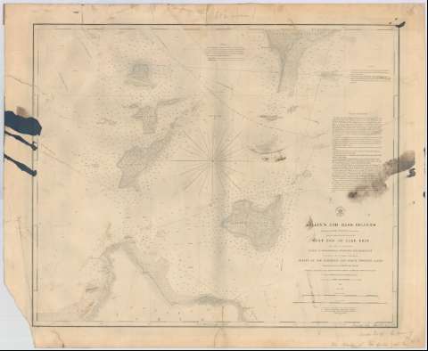
Kelly's and Bass Islands : showing the Harbors of Refuge...


 Maps, plans and nautical charts
Kelly's and Bass Islands : showing the Harbors of Refuge in their Vicinity being an extract from the west survey of... (1852)
Maps, plans and nautical charts
Kelly's and Bass Islands : showing the Harbors of Refuge in their Vicinity being an extract from the west survey of... (1852)
 Disponible Holdings
 Section: Maps, plans and nautical charts
Title: Kelly's and Bass Islands : showing the Harbors of Refuge in their Vicinity being an extract from the west survey of the west end of Lake Erie / made under the direction of the bureau of topographical engineers, war department in obedience to Acts of Congress requiring the survey of the northern and north western lakes ; triangulation by lieut. J.N. Macomb Corps top. engineers. : Hidrography & topography by lieuts. Macomb [et al.] and Messrs. Burgess, Peter & Forter ; assistant's under the orders of lieut. col. Kearney, Corps top. Engrs ; reduced for engraving by John Lambert draughtsman ; engraved by W.H. Dougal, Lettering by J.W.N. Throop under the Direction of capt. T.J. Lee Corps topl. engrs. Washington, December 1852
Material or type of resouce Area: Escala 1:50000 (O 82°54'--O 82°33'/N 41°45'--N 41°42')
Publication: [Washington] : Bureau of Topographical engineers, war departament, 1852
Physical description: 1 carta náutica ; 51 x 61 cm
Content type: Imagen cartográfica
Media type: computadora
Carrier type: recurso en línea
Notes: Escala también dada en forma gráfica de 6000 yardas y 5 millas estatutarias. Orientado con flecha en nudo de rumbos
Indica sondas batimétricas
Materia / lugar / evento: Cartas náuticas
Islas
1852
South Bass (Isla)
Other authors: Macomb, J. N
Dougal, W. H
Burgess
Peter
Forter
Kearney, James
Lee, T.J
Lambert, John
Throop, J.W.N
Estados Unidos. War Department. Engineer Bureau
UDC: 771-17
Type of publication:
Maps
Rights:
Préstamo:
Disponible
