General topographical map. Sheet XIII : [U.S.A,...


 Maps, plans and nautical charts
General topographical map. Sheet XIII : [U.S.A, Mississipi, Alabama and Georgia] (189-?)
Maps, plans and nautical charts
General topographical map. Sheet XIII : [U.S.A, Mississipi, Alabama and Georgia] (189-?)
 Disponible Holdings
 Section: Maps, plans and nautical charts
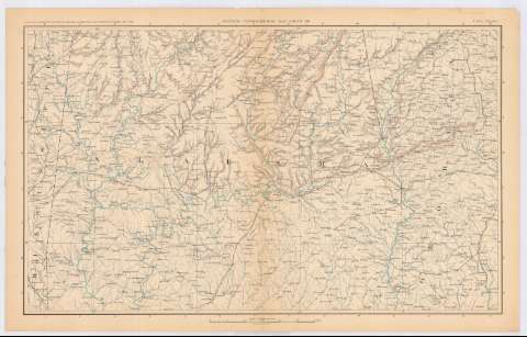
Title: General topographical map. Sheet XIII : [U.S.A, Mississipi, Alabama and Georgia]
Material or type of resouce Area: Escala [ca. 1:633594], 10 miles to 1 inch (O88 30'-O84 05'/N33 55'-N31 30')
Publication: Washington : Government Printing Office, [189-?] (N.Y. [Nueva York] : Julius Bien & co.)
Physical description: 1 mapa : col. ; 42x70 cm, en h. de 47x75 cm
Content type: Imagen cartográfica
Media type: computadora
Carrier type: recurso en línea
Notes: En : Atlas to accompany the Official Records of the Union and Confederate Armies 1861 - 1865. - Plate CXLVIII
Relieve : Lineas perpendiculares normales
En : . Atlas to accompany the Official Records of the Union and Confederate Armies 1861 - 1865
Materia / lugar / evento: Guerra civil
Mapas topográficos
Redes de transporte
Divisiones administrativas
Ríos
S.XIX
Mississippi
Alabama
Georgia (Estados Unidos)
Estados Unidos
UDC: 912:355.4(762+761+758)'1861/1865'
912:528.4(73-11)'1861/1865'
762)
761
758
Type of publication:
Maps
Rights:
Préstamo:
Disponible
