Territory and Military Department of Utah


 Disponible Holdings
 Section: Maps, plans and nautical charts
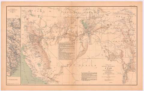
Title: Territory and Military Department of Utah / compiled in the Bureau of Topograph. Engrs. of the War Departt. chiefly for Military purposes under the authority of Mon. J.B. Floyd, Sec. of War 1860
Material or type of resouce Area: Escala [ca. 1:2554524], 100 statute mile [= 6,3 cm] (O123 -O105 / N43 -N34)
Publication: Washington : Government Printing Office, [189-?] (N.Y. [Nueva York] : Julius Bien & co.)
Physical description: 1 mapa : col. ; 42 x 62 cm, en h. de 47 x 75 cm
Content type: Imagen cartográfica
Media type: computadora
Carrier type: recurso en línea
Notes: Relieve representado por normales
Coordenadas: (O123 -O105/N43 -N34)
Figura en el margen inferior: "General Map"
Representadas mediante color azul las posiciones del ejército de la Unión
Figura texto de 'Authorities'
Nota explicativa de la construcción del mapa
En : Atlas to accompany the Official Records of the Union and Confederate Armies 1861-1865. P. CXX, nº 1
Materia / lugar / evento: Guerra civil
Mapas militares
Itinerarios
1860
California
Nevada
Colorado
Estados Unidos
Other authors: Estados Unidos. War Department. Engineer Bureau
UDC: (792)
Type of publication:
 Maps
Maps
Rights:
Préstamo:
Disponible
