Rebel lines. Mobile defenses. Fort Jeb Stuart, K. : [plan]


 Maps, plans and nautical charts
Rebel lines. Mobile defenses. Fort Jeb Stuart, K. : [plan] (189-?)
Maps, plans and nautical charts
Rebel lines. Mobile defenses. Fort Jeb Stuart, K. : [plan] (189-?)
 Disponible Holdings
 Section: Maps, plans and nautical charts
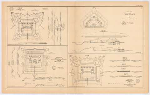
Title: Rebel lines. Mobile defenses. Fort Jeb Stuart, K. : [plan] / on lieut. Col. V. Sheliha's line of works
Material or type of resouce Area: Escala [ca. 1:824], 100 feet [= 3'7 cm]
Publication: Washington : Government Printing Office, [189-?] (N.Y. [Nueva York] : Julius Bien & co.)
Physical description: 1 plano ; 20x31 cm, en h. de 47x75 cm
Content type: Imagen cartográfica
Media type: computadora
Carrier type: recurso en línea
Notes: En : Atlas to accompany the Official Records of the Union and Confederate Armies 1861-1865. - Plate CVIII, n 1
Mapa que acompaña al informe del 'Maj. Gen. E.R.S. Canby, U.S. Army, dated New Orleans, La. June 1, 1865'
Figura en margen inferior : Series 1. Vol. XLIX
Figura rúbrica impresa
Inserta 6 secciones. Escala [ca. 1:739]
Figura sello con inscripción : 'made for Maj. Genl. E.R.S. Canby. Comdg.'
En : Atlas to accompany the Official Records of the Union and Confederate Armies 1861-1865
Materia / lugar / evento: Guerra civil
Fortalezas militares
Arquitectura militar
1865
Estados Unidos
Other authors: Sheliha, V Lieutenant Colonel
UDC: 912:355.4]:[623.1+725.18](781 Fort Jeb Stuart)'1865'
781 Fort Jeb Stuart
Type of publication:
Maps
Rights:
Préstamo:
Disponible
