Central Virginia, showing Maj. Gen. P.H. Sheridan's...


 Maps, plans and nautical charts
Central Virginia, showing Maj. Gen. P.H. Sheridan's campaings and marches of the Cavalry under lus command in... (189-?)
Maps, plans and nautical charts
Central Virginia, showing Maj. Gen. P.H. Sheridan's campaings and marches of the Cavalry under lus command in... (189-?)
 Disponible Holdings
 Section: Maps, plans and nautical charts
Uniform title: VIRGINIA (Estados Unidos) (Estado). Central. Operaciones bélicas. 189. 1:785039 (1864-1865)
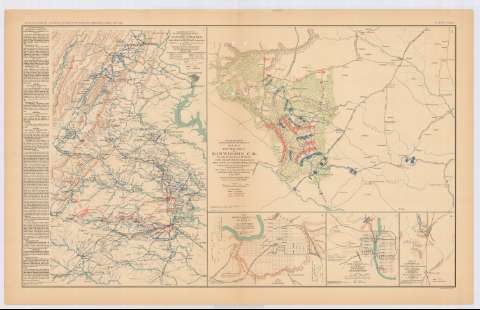
Title: Central Virginia, showing Maj. Gen. P.H. Sheridan's campaings and marches of the Cavalry under lus command in 1864-1865 : [map] / drawn and lithograped under direction of But. Maj. Gen. L. Gillespie, USA, Chief Eng. Military of the gulf, october 1865 ; Engineer Bureau, War Department
Material or type of resouce Area: Escala [ca. 1:785039], 20 miles [= 4,1 cm]
Publication: Washington : Government Printing Office, [189-?] (N.Y. [Nueva York] : Julius Bien & co.)
Physical description: 1 mapa : col. ; 42x30 cm, en h. de 47x75 cm
Content type: Imagen cartográfica
Media type: computadora
Carrier type: recurso en línea
Notes: En : Atlas to accompany the Official Records of the Union and Confederate Armies 1861-1865. - Plate LXXIV, n 1
Relieve : líneas perpendiculares normales
Orientado con flecha
Leyenda de signos utilizados
Inserta texto de : 'Routes of the raids / made by the Cavalry, under Major General P.H. Sheridan'
Mapa que acompaña al informe del : Maj. Gen. P.H. Sheridan
Figura en margen inferior izquierdo : Series 1 Vol XLVI
En : Atlas to accompany the Official Records of the Union and Confederate Armies 1861-1865
Materia / lugar / evento: Guerra de Secesión
Operaciones bélicas
Estrategia
Mapas militares
Planos de población
Líneas ferroviarias
Itinerarios
1861-1865
1865
Washington, D.C
Fredericksburg (Estados Unidos, Virginia)
Richmond
Petersburg
Estados Unidos
UDC: 912:355.4]:[355.4+355.43+625.1656.02](755-191.2)'1864/1865'
912:355(755 -191.2)'1864/1865'
912:314(753)(084.3)
912:314(755 Fredericksburg)(084.3)
912:314(755 Richmond)(084.3)
912:314(755 Petersburg)(084.3)
755-191.2
Type of publication:
Maps
Rights:
Préstamo:
Disponible
