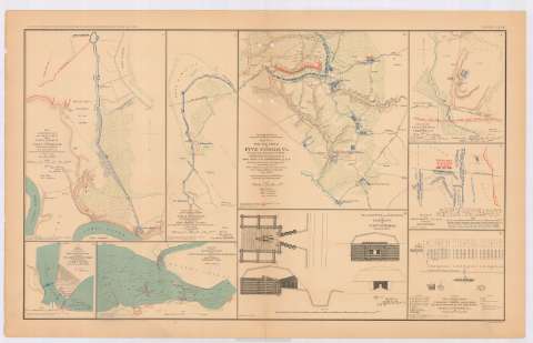
Defensive lines 18th. Army Corps from Fort Brady to Fort...


 Maps, plans and nautical charts
Defensive lines 18th. Army Corps from Fort Brady to Fort Burnham, (Battery Harrison) : in the field, october 1864 :... (189-?)
Maps, plans and nautical charts
Defensive lines 18th. Army Corps from Fort Brady to Fort Burnham, (Battery Harrison) : in the field, october 1864 :... (189-?)
 Disponible Holdings
 Section: Maps, plans and nautical charts
Title: Defensive lines 18th. Army Corps from Fort Brady to Fort Burnham, (Battery Harrison) : in the field, october 1864 : [map] / chief Engineer's Office, Department Virginia and North Carolina
Material or type of resouce Area: Escala [ca. 1:13268], 2000 feet [= 4,6 cm]
Publication: Washington : Government Printing Office, [189-?] (N.Y. [Nueva York] : Julius Bien & co.)
Physical description: 1 mapa : col. ; 31x21 cm, en h. de 47x75 cm
Content type: Imagen cartográfica
Media type: computadora
Carrier type: recurso en línea
Notes: En : Atlas to accompany the Official Records of the Union and Confederate Armies 1861-1865. - Plate LXVIII, n 1
Relieve : Líneas perpendiculares normales
Orientado con flecha
Mapa que acompaña al informe del 'Leint. P.S. Michie'
Figura en margen inferior izquierdo : Series 1. Vol. XLII. Part 1. Page 663
Figuran representadas con distintos colores las fuerzas de los dos ejércitos
Figura rúbrica impresa
En : Atlas to accompany the Official Records of the Union and Confederate Armies 1861-1865
Materia / lugar / evento: Guerra civil
Fortalezas militares
Estrategia militar
1864
Fort Brady
Fort Burnham
Estados Unidos
Other authors: Estados Unidos. Army. Office of the Chief of Engineers
UDC: 912:355.4]:[623.1+355.43](755)'1864'
755
Type of publication:
Maps
Rights:
Préstamo:
Disponible
