Campaign against Sterling Price, 1864


Section: Maps, plans and nautical charts
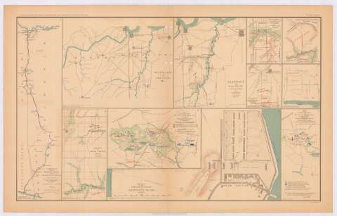
Title: Campaign against Sterling Price, 1864 / Maj. Gen. S.R. Curtis, Commanding ; executed under the direction of lieut. G.T. Robinson, chief engineer, by Jacob Miller...
Material or type of resouce Area: Escala indeterminada
Publication: Washington : Government Printing Office, [189-?] (N.Y. [Nueva York] : Julius Bien & co.)
Physical description: 1 mapa : col. ; 42x11 cm, en h. de 47x75 cm
Content type: Imagen cartográfica
Media type: computadora
Carrier type: recurso en línea
Notes: En : Atlas to accompany the Official Records of the Union and Confederate Armies 1861-1865. - Plate LXVI, n 1
Relieve : líneas perpendiculares normales
Orientado con flecha
Mapa que acompaña el informe del : Maj. Gen. S.R. Curtis
Figura en margen inferior : Series I. Vol. XLI. Part 1. Page 472
En : Atlas to accompany the Official Records of the Union and Armies 1861-1865
Materia / lugar / evento: Guerra civil
Operaciones bélicas
Carreteras
Divisiones administrativas
1864
Missouri
Arkansas
Estados Unidos
Other authors: Curtis, S.R Major General
Robinson, G.T Lieutenant
Miller, Jacob
UDC: (73)
Type of publication:
 Maps
Maps
Rights:
Préstamo:
 Disponible
