Map of the approaches to Petersbiurg and their defenses 1863


 Maps, plans and nautical charts
Map of the approaches to Petersbiurg and their defenses 1863 (189-?)
Maps, plans and nautical charts
Map of the approaches to Petersbiurg and their defenses 1863 (189-?)
 Disponible Holdings
 Section: Maps, plans and nautical charts
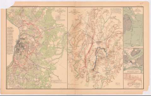
Title: Map of the approaches to Petersbiurg and their defenses 1863 / by order of the Engineer Bureau, Col. J.F. Gilmer CSE in charge of Bureau, Col. W.H. Stevens, CSE chief of Construction, Capt. Chas. H. Dimmock, CSE, in charge of Defenses Petersburg, VA
Material or type of resouce Area: Escala [ca. 1:39252], 1 mile [= 4,1 cm]
Publication: Washington : Government Printing Office, [189-?] (N.Y. [Nueva York] : Julius Bien & co.)
Physical description: 1 mapa : col. ; 42x31 cm, en h. de 47x75 cm
Content type: Imagen cartográfica
Media type: computadora
Carrier type: recurso en línea
Notes: En : Atlas to accompany the Official Records of the Union and Confederate Armies 1861 - 1865. - Plate XL, n 1
Relieve : Líneas perpendiculares normales
Orientado con flecha
Leyenda de signos que tipifican cultivos
Figura relación numérica de baterías militares
Figura nota explicativa de la lectura de los colores
En : Atlas to accompany the Official Records of the Union and Confederate Armies 1861 - 1865
Materia / lugar / evento: Guerra civil
Fortificaciones
Baterías
Carreteras
Líneas ferroviarias
Planos de población
1863
Petersburg
Estados Unidos
Other authors: Dimmock, H
Gilmer, J. F
Stevens, W. H
UDC: 912:355.4]:[623.1+623.2+625.7+625.1](755)'1863'
912:314(755 Petersburg) (084.3)
755
Type of publication:
Maps
Rights:
Préstamo:
Disponible
