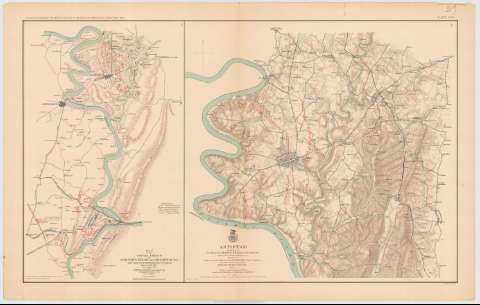
Map of the battle - fields of Harper's Ferry and Shar...


 Maps, plans and nautical charts
Map of the battle - fields of Harper's Ferry and Shar psburg : with position of troops, routes of Army & c. Sept.... (189-?)
Maps, plans and nautical charts
Map of the battle - fields of Harper's Ferry and Shar psburg : with position of troops, routes of Army & c. Sept.... (189-?)
 Disponible Holdings
 Section: Maps, plans and nautical charts
Title: Map of the battle - fields of Harper's Ferry and Shar psburg : with position of troops, routes of Army & c. Sept. 13 to 17. 1862 / by S. Howell Brown, 1st. Lieut. Engr. Troops in charge topl. Dept. A.N.V. Jan 27 1864
Material or type of resouce Area: Escala [ca. 1:61897], 2 miles [5'2 cm]
Publication: Washington : Government Printing Office, [189-?] (N.Y. [Nueva York] : Julius Bien & co.)
Physical description: 1 mapa : col. ; 42x26 cm, en h. de 47x75 cm
Content type: Imagen cartográfica
Media type: computadora
Carrier type: recurso en línea
Notes: En : Atlas to accompany the Official Records of the Union and Confederate Armies 1861 - 1865. - Plate XXIX, n 1
Relieve : Líneas perpendiculares normales
Leyenda de símbolos
En el margen inferior figura : 'Series 1. Vol. XIX. Part 1. Page 139
Representadas en distintos colores la disposición y movimientos de las tropas de ambos ejércitos
En : Atlas to accompany the Official Records the Union and Confederate Armies 1861 - 1865
Materia / lugar / evento: Guerra civil
Batallas
Arma de Artillería
Estrategia militar
Itinerarios
Líneas ferroviarias
1862
Harpers Ferry
Estados Unidos
Other authors: Brown, S. Howell 1st. Lieutenant Ongineer Topographical
UDC: 912:355.4]:[355.422+358.1+355.43+656.02+625.1](752 Shaspshurg)
752 sharpsburg
Type of publication:
Maps
Rights:
Préstamo:
Disponible
