Reconnaissance of Secession Works and plan of siege of...


 Maps, plans and nautical charts
Reconnaissance of Secession Works and plan of siege of Yorktown : April and May 1862 (189-?)
Maps, plans and nautical charts
Reconnaissance of Secession Works and plan of siege of Yorktown : April and May 1862 (189-?)
 Disponible Holdings
 Section: Maps, plans and nautical charts
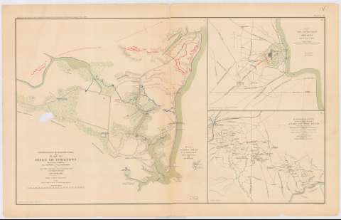
Title: Reconnaissance of Secession Works and plan of siege of Yorktown : April and May 1862 / made under orders of Genl. Bornard and Maj. Humphreys ; by lieut Abbot, top. Engrs, Lieut. Constock, Engrs, Lieut Wagner, top. Engrs.
Material or type of resouce Area: Escala [ca. 1:14560], 2000 [= 12'5 cm]
Publication: Washington : Government Printing Office, [189-?] (N.Y. [Nueva York] : Julius Bien & co.)
Physical description: 1 mapa : col. ; 41x43 cm, en h. de 47x75 cm
Content type: Imagen cartográfica
Media type: computadora
Carrier type: recurso en línea
Notes: En : Atlas to accompany the Official Records of the Union and Confederate Armies 1861 - 1865. - Plate XIV, n 1
Relieve : lineas perpendiculares normales
Orientado con flecha
Mapa n 1 del sitio, acompaña al informe del Chief Engr. U.S.A.
Figura en margen inferior : Series 1. Vol XI. Part 1. Page 316
En : Atlas to accompany the Official Records of the Union and Confederate Armies 1861 - 1865
Materia / lugar / evento: Guerra civil
Sitios
Fortificaciones
Estrategia
1862
Yorktown
Estados Unidos
Other authors: Abbot, Henry L
Comstock, Cyrus Ballou
Barnard, J. G (John Gross), 1815-1882
Wagner Lieut
Humphreys, A. A (Andrew Atkinson), 1810-1883
UDC: 912:355.4]:[355.44+623.2+355.43](755)'1862'
755
Type of publication:
Maps
Rights:
Préstamo:
Disponible
