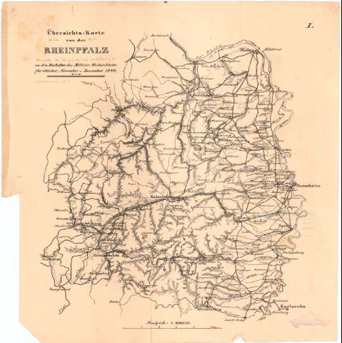
Ubersichts - Karte von der Rheinplalz : zu den Beihelten...


 Maps, plans and nautical charts
Ubersichts - Karte von der Rheinplalz : zu den Beihelten des Militair Wochenblatts flur Oktober, November u... (1849 ?)
Maps, plans and nautical charts
Ubersichts - Karte von der Rheinplalz : zu den Beihelten des Militair Wochenblatts flur Oktober, November u... (1849 ?)
 Disponible Holdings
 Section: Maps, plans and nautical charts
Title: Ubersichts - Karte von der Rheinplalz : zu den Beihelten des Militair Wochenblatts flur Oktober, November u Dezember, 1849, u.s.w. / [Of. Top. del E.M.]
Material or type of resouce Area: Escala 1:400000
Publication: [Alemania ? : [Editor no identificado], 1849 ? ]
Physical description: 1 mapa ; 36,7x36,4 cm
Content type: Imagen cartográfica
Media type: computadora
Carrier type: recurso en línea
Notes: Mención de responsabilidad tomada del Catálogo del SG : 'Alemania. - Siglos XVII a XIX'. 1976, p. 134
Relieve representado por normales
En el ángulo superior derecho : 'I'
Procede de la 'Colección Rico y Sinobas'
Materia / lugar / evento: Operaciones bélicas
1849
Zweibrucken
Maguncia
Karlsruhe
UDC: 912:355.4(430-328 Renania-Palatinado)'1849'
(430 Zweibrucken)
(430 Maguncia)
(430 Karlsruhe)
Type of publication:
Maps
Rights:
Préstamo:
Disponible
