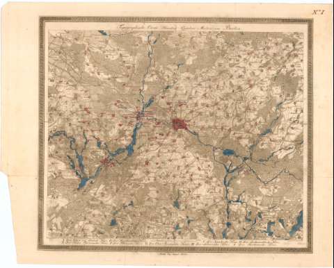
Topographische Carte Hundert Quadrat Meileu um Berlin


 Maps, plans and nautical charts
Topographische Carte Hundert Quadrat Meileu um Berlin (im Fuhr. 1811)
Maps, plans and nautical charts
Topographische Carte Hundert Quadrat Meileu um Berlin (im Fuhr. 1811)
 Disponible Holdings
 Section: Maps, plans and nautical charts
Uniform title: BRANDEBURGO (Alemania). Mapas generales. 1:90000 (1811)
Title: Topographische Carte Hundert Quadrat Meileu um Berlin / bey August Rucker ; gestochen von Lud Sckmidt
Material or type of resouce Area: Escala [ca. 1:90000], 2 Meileu [= 8 cm]
Publication: Berlin : Herausgegeben von F. Schneider Kon, Sreusf, im Fuhr. 1811
Physical description: 1 mapa : col. ; 41'5x49 cm en h. de 47x56 cm
Content type: Imagen cartográfica
Media type: computadora
Carrier type: recurso en línea
Notes: Relieve representado por normales
Indica cultivos y el curso del rio con flecha
En el margen superior derecho N I
Other authors: Rucker, August
Schmidt
Schneider, F
UDC: 912(430-328 Bradenburgo)'1811'
430-328 Bradenburgo
Type of publication:
Maps
Rights:
Préstamo:
Disponible
