Territory of the United States from the Mississippi River...


 Maps, plans and nautical charts
Territory of the United States from the Mississippi River to the Pacific Ocean : Originally prepared to accompany... (1873?)
Maps, plans and nautical charts
Territory of the United States from the Mississippi River to the Pacific Ocean : Originally prepared to accompany... (1873?)
 Disponible Holdings
 Section: Maps, plans and nautical charts
Uniform title: ESTADOS UNIDOS. O. Mapas generales. 1:3000000 (1873)
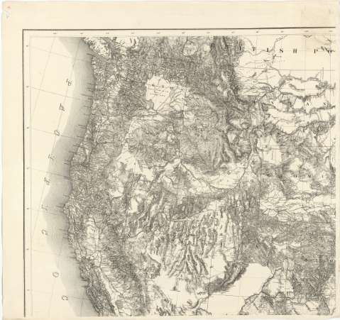
Title: Territory of the United States from the Mississippi River to the Pacific Ocean : Originally prepared to accompany the Reports of the Explorations for a Pacific Railroad route ; made in accordance with the 10 th. & 11 th. section of the Army appropriation, Act of march 3rd. 1853 / Compiled from authorized explorations and other reliable data by Lieut. G. K. Warren, Topl. Engrs. in the office of Pacific R.R. Surveys, War Dept. under the direction of But. Maj. W. H. Emory, topl. Engrs. in 1854, Capt. A.A. Humphreys, Topl. Engrs. in 1854-1858 ; Recompiled and redrawn under the direction of the chief of Corps of Engineers by Edward. Freyhold 1865-66-67-68
Material or type of resouce Area: Escala 1:3000000 ; [proy. esterográfica oblicua]
Publication: [Washington] : Head Quarters Corps of Engineers War Department, 1873?
Physical description: 1 mapa en 4 h. ; 108 x 127 cm en h. de 61 x 64 cm
Content type: Imagen cartográfica
Media type: computadora
Carrier type: recurso en línea
Notes: En el margen inferior derecho aparece una relación de autoridades cuyas expediciones han servido para la realización y levantamiento del mapa
Fecha de publicación tomada de una nota en la que se indica "Rail Road corrected june 5th. 1873"
Escala gráfica de 200 millas estatutarias [= 10'5 cm]. Coordenadas referidas a un meridiano que no se especifica (O 132°-O 84°/N 50°-N 22°). Red geográfica de 2º en 2º
Relieve representado por normales
Inserta: "Territory of Alaska ceded by Russia to the United States. 1868". Escala 1:9000000
Materia / lugar / evento: Mapas generales
Ríos
Costas
Océanos
1873
Mississippi
Alaska
Pacífico
Estados Unidos
Other authors: Warren, Gouverneur Kemble, 1830-1882
Emory, William Hemsley
Humphreys, A. A (Andrew Atkinson), 1810-1883
Freyhold, Edward
Estados Unidos. War Department
Estados Unidos. Army. Corps of Engineers
UDC: 912(73-15)"1873"
73-15
Type of publication:
Maps
Rights:
Préstamo:
Disponible
