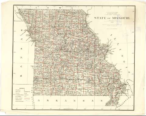
State of Missouri


Section: Maps, plans and nautical charts
Title: State of Missouri / Department of the Interior, General Land Office; J.A. Williemson, Commissioner; compiled from tre official Record of the General Land Office and other sources by C. Roeser, principal Draufhtsman G.L.O.
Material or type of resouce Area: Escala [1:887040 ; proy. cónica equidistante] (O 95°30'--O 89°00' / N 40°30'--N 36°00')
Publication: N.Y. [i.e. New York] : Photo lith & print by Julius Bien, 16 & 18 Park Place, 1878
Physical description: 1 mapa : col. ; 64 x 75 cm
Content type: Imagen cartográfica
Media type: computadora
Carrier type: recurso en línea
Notes: Escala nominal de 14 millas por pulgada y gráfica de 50 millas estatutarias [= 9'3 cm]. Coordinadas también referidas al meridiano de Washington (O 18° 30'--O 12° 00'). Red geográfica de 1° en 1°
Sobre el mapa aparece trazada una retícula marcadas con números arábigos las abcisas y romanos las ordenadas, que parece en un sistema de localización de aquellos municipios sobre los que han realizado mediciones catastrales
Tabla de los signos convencionales para indicar: la situación de las llamadas "U.S. Land Offices", los núcleos de población destacándose la capital del estado y condado, los límites entre éstos últimos y lineas ferroviarias
Ingresa en rojo y verde
Materia / lugar / evento: Divisiones administrativas
Mapas generales
Municipios
Other authors: Williamson, J.A
Bien, Julius, 1826-1909
Roeser, C
Estados Unidos. Department of the Interior. General Land Office
UDC: 912(778-28)"1878"
778
Type of publication:
 Maps
Maps
Rights:
Préstamo:
 Disponible
