Puerto de Pasajes


Section: Maps, plans and nautical charts
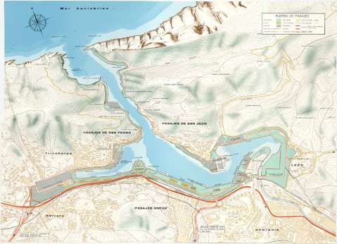
Title: Puerto de Pasajes / Ministerio de Obras Públicas, Dirección General de Puertos y Señales Marítimas, Junta del Puerto de Pasajes, 1974
Material or type of resouce Area: Escala 1:5000
Publication: [Lugar de publicación no identificado] : M.O.P., 1974?]
Physical description: 1 mapa : col. ; 57 x 77 cm
Content type: Imagen cartográfica
Media type: computadora
Carrier type: recurso en línea
Notes: Tútulo, mención de responsabilidad y pié de imprenta tomados del catálogo del SGE: "Región Vasco-Navarra Provincia de Guipúzcoa. Siglos XVI a XIX Inclusive". 1969, p. 236-2°, en el que consta que el presente documento pertenece a la memoria publicaca en 1974 por la Junta del Puerto de Pasajes, M.O.P., Dirección General de Puertos y Señales Marítimas
Coordenadas del puerto referidas al meridiano de Greenwich (O 1°56'/N 43°20'). Orientado con rosa de dieciseis vientos inscrito en circulo
Orografía por curvas de nivel equidistantes 5 metros y por el dibujo convencional de la forma del roquedo
Indica sondas batimétricas
Presenta los planos de las poblaciones de Pasajes de San Juan, Pasajes de San Pedro, Pasajes Ancho, Herrera, Lezo y parte de Rentería
Relación de los edificios e instalaciones del puerto de Pasajes indicadas por clave cromática
Tabla de signos convencionales para indicar carreteras, ferrocarriles, límites municipales y de la zona portuaria
Materia / lugar / evento: Mapas topográficos
Instalaciones portuarias
Planos de población
1974
Guipúzcoa
País Vasco
Other authors: España. Ministerio de Obras Públicas
España. Dirección General de Puertos y Señales Marítimas
Junta del Puerto de Pasajes
UDC: 912:[314(084.3)]:627.3(466.212:26.04)"1974"
466.212:26.04 Pasajes
Type of publication:
 Maps
Maps
Rights:
Préstamo:
 Disponible
