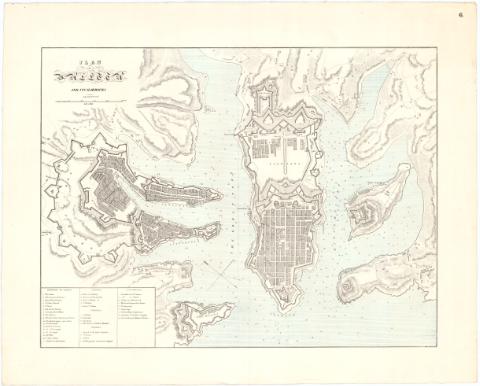
Plan of Valetta and its harbours


Section: Maps, plans and nautical charts
Uniform title: LA VALLETA (Malta). Cartas náuticas. 1:9000 (184)
Title: Plan of Valetta and its harbours / Luigi Brocktorff Litht.
Material or type of resouce Area: Escala [ca. 1:9000], 2640 féet [= 8,6 cm]
Publication: [Londres ? : s.n., 184- ?]
Physical description: 1 mapa ; 38,5x50,8 cm en h. de 49,3x61,7 cm
Notes: Orientado con flecha indicando N. magnético y N. verdadero
Relieve representado por sombreado y normales
Indica batimetría
Relación de principales edificios de la ciudad según zonas indicados por clave numérica
En el margen superior derecho : 6
Indica fortificaciones, arsenales, carreteras, accidentes geográficos y cultivos
ITL
Materia / lugar / evento: Cartas náuticas
Planos de población
Fortificaciones
Siglo XIX
Other authors: Brocktorff, Luigi
UDC: 912:551.46]:(623.2)(458.2)'1840/1849'
912:314(458.2 Valletta)'1840/ 1849'(084.3)
(458.2 Valletta)
Type of publication:
 Maps
Maps
Rights:
Préstamo:
 Disponible
