Plan of the Port of Chaoul on the Coast of Concan...


 Maps, plans and nautical charts
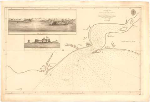
Plan of the Port of Chaoul on the Coast of Concan Belonging to the Mahrattas Lat. 18°.32'.20''. N. Long.... (1784)
Maps, plans and nautical charts
Plan of the Port of Chaoul on the Coast of Concan Belonging to the Mahrattas Lat. 18°.32'.20''. N. Long.... (1784)
 Disponible Holdings
 Section: Maps, plans and nautical charts
Uniform title: India. Cartas náuticas (1784). 1:46000
Title: Plan of the Port of Chaoul on the Coast of Concan Belonging to the Mahrattas Lat. 18°.32'.20''. N. Long. 69°.36'.25''. E. fr. París. From a French MS. Communicated by Govr. Horuby to Whom this Plate is inferibed / By His most obliged A. Dalrymple ; WH.
Material or type of resouce Area: Escala [ca. 1:46000]
Publication: [London ?] : Publish'd according to Act. of Parliament by A. Dalrymple Novr. 1st..., 1784
Physical description: 1 carta náutica ; 33,9x50,2 cm
Content type: Imagen cartográfica
Media type: computadora
Carrier type: recurso en línea
Notes: Presenta además 2 vistas
Escala hallada a partir de un minuto de la latitud [= 4 cm]
Orientado con lis en nudo de rumbos
Relieve representado por sondas batimétricas
Indica veriles, bajos, fondeaderos y la dirección del río con flecha
Sello de la Hydrographical Office
Other authors: Harrison, W
Dalrymple, Alexander
UDC: 912:[551.46:627.22](540-15)'1784'
540-15
Type of publication:
Maps
Rights:
Préstamo:
Disponible
